About Us
Pathfinder Drone, based in Hampshire, is a family owned and operated business committed to the highest levels of service, safety, technology and innovation.

Pathfinder Drone blends more than 50 years of traditional construction and engineering methods with the latest aerial and terrestrial technology to provide clients with a cost-effective solution for their needs.
Whether it’s an inspection of a large industrial site or surveying land for development, Pathfinder Drone can help. Our family business ethos means we are always happy to go the extra mile for clients, ensuring they receive the best possible service.
At Pathfinder, we prioritise safety, quality, and professionalism. We recognise that these standards are non-negotiable in delivering the best possible service to our clients.
Our team is dedicated to constantly improving and maintaining the highest levels of safety in all aspects of our work, alongside the highest quality data and services.
Our aim is to constantly exceed expectations and provide the best quality at reasonable costs. We stand by our commitment to these standards in every aspect of our business.
Our Equipment
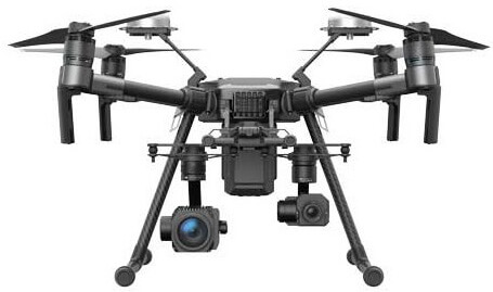
Matrice 300 RTK
The DJI M300 drone is a versatile and efficient payload solution for commercial applications. Its payload versatility allows it to carry a wide range of payloads up to 2.7kg and its impressive flight time of up to 55 minutes gives it significant capability for long-distance tasks.
The M300’s triple modular redundant design ensures continued operation even in the event of component failure, making it an effective choice for critical operations such as power line or infrastructure inspections.
Combined with advanced flight control technology and our range of task specific flight software, the M300 offers reliable, efficient performance for a wide range of industries and applications.
Matrice 210 RTK
The DJI M210 RTK is one of our oldest drones but is still a versatile piece of kit designed for industrial use.
With a wide range of payloads including thermal and RGB cameras for solar panel inspections, and precise mapping and surveying.
The RTK feature allows for highly precise navigation in real time, making it ideal for missions such as assessing powerline infrastructure or bridges. With its durable build and advanced technology, the M210 RTK is a valuable tool in our arsenal. Furthermore, its flight control system enables automated flight functions such as waypoint navigation, making it easy to efficiently gather data on large scale projects.
Overall, the DJI M210 RTK is a reliable choice for professionals in need of top-notch aerial imaging capabilities.
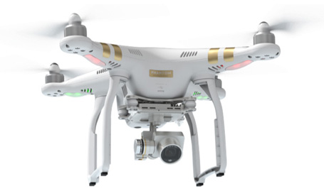
Phantom 4 RTK
The DJI Phantom 4 RTK is a highly effective and portable drone for surveying and mapping tasks. Its precise real-time kinematics technology allows for accurate image capture, making it suitable for industries such as construction and agriculture.
Additionally, it features an advanced obstacle avoidance system and long flight time, leading to increased safety and efficiency in operation. With its range of capabilities and innovative technology, the Phantom 4 RTK occupies a key role within Pathfinder as a daily workhorse.
Mini 2
The DJI Mini 2 is a compact and surprisingly powerful drone, capable of capturing high-quality video footage and images. One of its standout features is the extremely low weight, bringing it under legislation covering drones under 250g.
Stabilised camera technology allows for smooth and stable movement during flight. It can stay airborne for almost 30 minutes on one charge. Additionally, it boasts noise reduction technology for quieter flight experience and improved aerial photography opportunities.
With its impressive capabilities and compact size, the DJI Mini 2 is a valuable tool for Pathfinder when operating in heavily congested or sensitive environments.
Trimble S7 Total Station
When it comes to precision and reliability, the Trimble S7 sets the standard. With advanced tilt compensation technology and an intuitive touch screen interface, this total station allows surveyors to work quickly and accurately in any environment.
The S7’s VISION capture feature enables the capture of high-resolution images and 360-degree panoramas for enhanced data documentation. Combined with its expandable memory and long battery life, the Trimble S7 is truly a powerhouse piece of surveying equipment.
Whether it’s on a construction site or out in the field, the S7 delivers consistent, reliable results every time.
Spectra SP85 GNSS
The spectra precision SP85 GNSS is a precision instrument designed for optimal accuracy in difficult environments. With full support for both GPS and GLONASS satellites, the SP85 offers reliable position information even in challenging conditions such as dense urban areas or heavily forested terrain.
The receiver also features an advanced anti-jamming system, ensuring precision measurements even in potential interference environments.
Trimble TSC7
The Trimble TSC7 is a versatile, touchscreen controller that allows for precision data collection in the field. With its durable design and long battery life, it can withstand rugged conditions while remaining reliable.
The TSC7 also features an intuitive interface and fast processing speed, making it easy for users to quickly gather accurate data. In addition, it can integrate with a variety of Trimble software solutions, allowing for efficient workflow and seamless data management.
Overall, the Trimble TSC7 is a valuable tool for improving precision and reliability in field work.
Pix4D
Photogrammetry is a method of collecting data using aerial or terrestrial photographs, and Pix4D is at the top of the industry when it comes to photogrammetry software.
The program offers topographic modelling capabilities, creating detailed topographical maps using the collected data. It also produces point clouds, which provide even greater detail and accuracy for surveying and construction projects.
We run Pix4D in house and own the software outright so you know you aren’t overpaying for short term licenses.
We often do work to repair poor quality datasets from inexperienced operators so you can rest assured that we have the experience to deliver the data you need.