Most people are aware of the fantastic photos that drones can produce and what they can do for photographers but what is less understood is the role they can play in site engineering. Pathfinder Drone is a team of construction professionals dedicated to bringing the best drone technology to the construction and civil engineering sectors.
Our team has combined experience of over 40 years in the industry and understands what you need to get the job done.
Pathfinder have some of the latest RTK mounted drones on the market, and always certify our surveys using ground control. In air RTK and ground control provides high levels of “absolute accuracy” and our data capture techniques combined with specialist software provide high levels of “relative accuracy” meaning you can rest assured that all of our data can be relied upon for whatever you need.
Key Benefits
Safety – with no working at height involved or confined space entry to excavations, you can be sure that all of your team are safe. Keep people and plant separate, no more surveyors working in and around excavators, walking next to dump trucks on the haul road or grabbing spot levels in between dozer pushes.
Time – Accurate and high resolution GPS surveying takes time, for larger sites of over 30 acres this may take a whole week. We can plan and mobilise survey works of up to 100 acres then process the survey and have usable data delivered to you within 48 hours if required. On jobs where program is tight, or the QS needs information quickly for your invoice, this is all possible.
Snapshot Reporting – With out surveys being undertaken usually within a 1 hour slot, all the information is as live as possible. Weekly progress updates can give a snapshot of progress so you know all the information is current, up to date and provides accurate data continuity.
Cost – With surveys from as little as £650, prices are comparable to standard site surveyor. Whilst a drone can’t do your setting out, the amount of data it can capture in the same time is much greater, saving you time and money.
Use point clouds for virtual surveying
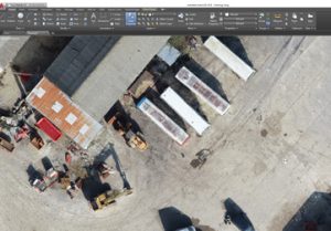
With 3D models created in our software, you can import .las or Autodesk ReCap models into AutoCAD or Civil 3D for virtual surveying. You’ll never miss a feature again, with the ability to go back and add or remove features on your drawings any time, with the capacity to get survey grade results on dozens of acres in only a few hours the time saved is incredible and with reporting times of under 48 hours, you’ll always have the data you need, when you need it.
Tracing outlines of site features will give you accuracy of under 30mm, and it works in full 3D for profiles of buildings and structures. Take the hard work and risk out of surveying excavation banks, embankment elevations and cliff faces by importing your models into AutoCAD and surveying with the click of a button.
Stockpile reports
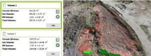
Generation of stockpiles reports can be done quickly and easily with a much higher degree of accuracy that standard surveying. Topographic surveying can produce cut fill data for an area, and with a formation shape file it can do all of your cut/fill work within minutes.
3D site visualisation
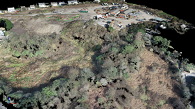
Use our cloud functionality to view your site in 3D, we provide a viewing platform and all imagery free of charge. When planning site works, understanding the area you are working with is critical, from managing haul roads, site offices, welfare, lay down zones, and stockpiling areas visualising the site in 3D gives your project team a unique perspective. Easily accessed from any browser on PC, Mac or mobile device, demonstrate to clients, subcontractors or the local residents exactly what your plans are and how you intend to complete the project with maximum safety and minimal disruption.
Details
For more details about us, our pilots or our work, feel free to get in touch or check out our website
01329 887337